
Ha Giang is the province we decided to explore after Hanoi and Cat Ba. It is the northernmost province of Vietnam, located just a stone’s throw away from the Chinese border. It is not a region that has historically been targeted by tourists due to its reputation as being one of Vietnam’s most wild and remote.
So why did we decide to go?
For the mountains. We went to see Ha Giang’s massive, countless and beautiful mountains.
The first step was getting there. The options were very limited so we opted for the only one that fit our budget: an overnight bus from Hanoi to Ha Giang City. We were told the ride would last approximately 8h (add here 2h or 3h to account for the fact that we were in Vietnam). I’ve taken overnight trains in China and in Thailand, so I figured this wouldn’t be much different. On this point, I was only half right. Although the bus was, in fact, relatively comfortable, it lacked a very important characteristic: a bathroom. Those who know me know I have a bladder the size of a peanut so the idea of being trapped on a bus for 8h to 10h without access to a bathroom really freaked me out. In the end, it was a smooth ride, if you don’t consider the bus lurching from one side to the other as the driver madly navigates through traffic. We arrived bright and early – i.e. 5AM – in Ha Giang. The city was dead silent and pitch black, so the driver very kindly allowed us to sleep in the bus for as long as we needed, while he caught a little bit of shuteye himself. We were so grateful!
The following morning, we started our 4 day motorbike adventure. At this point, I was really quite glad to have taken a couple of scooters for a test drive in Cat Ba, otherwise I wouldn’t have made it through the first day. Don’t get me wrong, Julien was driving very safely, but these roads aren’t for the faint of heart.

Our journey brought us through villages tucked away in hidden valleys, where the villagers continue to live much as they have for the past century. The women still wear colorful traditional garments which makes them easy to spot from a distance as they slowly climb narrow paths where one misplaced step could have fatal consequences. It was astounding to see how these people have carved even the steepest mountain flank into terraces where crops can grow.

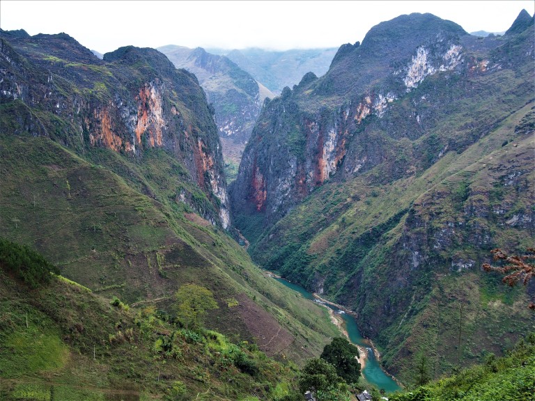
What captivated me the most were the mountain themselves. To quote Wiz Khalifa’s Sky High, it really felt like we were driving up roads “so high, we could touch the sky”. Cheesy, I know, but the feeling was real. My main highlight was definitely crossing the Ma Pi Leng Pass, on our third day. We drove up roads that twisted and turned through a moonlike terrain – this particular valley was strewn with jagged black limestone boulders – and eventually emerged on the other side of the mountain, where a canyon opened up before us. We had to stop for a moment to take it all in. Great stone cliffs, hundreds of meters high, in beautiful steel and copper hues stood on our left while a river with deep blue waters flowed at their feet. The surrounding mountains were equally majestic: the rich green vegetation that covered them like a cloak contrasted nicely with the clouds clinging at their peaks.

I was surprised by the cold. I had been warned that the northern mountains would be cool, but, being from Quebec, I thought nothing of it. I’ve seen many cold winters and haven’t been one to complain. This though, was something different. The humidity changes everything (and so does proper isolation), so I was obliged to go to bed fully dressed and shivering!
It really was an amazing adventure. The breathtaking scenery was definitely worth dodging oncoming tourist buses, braving the cold and sleeping in a couple of musty rooms.
Our adventure in numbers
- Days of traveling: 4
- Average hours of driving per day: 5 to 6
- Near accidents: 1 (Julien’s version of the story says a suicidal chicken threw itself at our front wheel. It definitely got a good scare and lost a few feathers in the process.)
- Times getting lost: 1 (It was in a cloud and we couldn’t see a thing. Thank you MAPS.ME for mapping even the smallest of dirt roads in the middle of no where.)
- Scrapped knees: 2 (Both mine and I wasn’t even on the motorbike: I spontaneously fell while walking down a hill.)
- Kilometers of jaw dropping scenery: 350
- Altitude at the Ma Pi Leng Pass, in meters: 1,500
- Waves to passing children: 1,000,000
PS: You’ll have to apologize for the small number of photos. The WIFI in Laos isn’t very reliable, so uploading new photos is nearly impossible.

Daphne – you should hang up your insurance underwriting hat and become a travel journalist and photographer. It feels like I’m right there with you guys hanging on the side of the mountains! I don’t need to hope, I know you and Julien are having a glorious adventure. Off to read another post.
LikeLike
Haha thank you so much Keith! More updates to come soon (we’re a little behind on our posts). We are having the time of our lives.
LikeLike
Absolutely spectacular scenery. It must have been a little nerve wracking being on a small moped on those high winding roads. I would imagine no one spoke English or French either. Quite the adventure.
LikeLike
Yeah, pretty scary at first but it wasn’t si bad in the end. The really scary thing was the crazy buses poping out of no where. They didn’t honk their horns to let people know they were coming and just appeared at 70km/h right out of no where!!
There were some English speakers, where people like us are known to stay for the night, but that’s it!
LikeLike